Moisture Mapping and Monitoring for Large Loss Insurance Claims
When it comes to managing large loss insurance projects, accurate moisture mapping and continuous monitoring are critical. Our state-of-the-art moisture mapping services deliver accurate assessments and ongoing monitoring to help insurance professionals and restoration experts minimize delays and miscommunication, streamlining claims.
Why Moisture Mapping Matters
Water damage can be deceptive, even to the experienced eye. Hidden moisture in building materials often leads to mold growth, structural deterioration, and claims disagreements. Our comprehensive moisture mapping services identify these hidden threats before they escalate, ensuring that:
Damage is found early: Early detection eliminates disagreements about the scope of damages, ensuring that all damage is accounted for in ROMs and initial walkthroughs.
Insurance claims are accurately documented: Detailed moisture maps provide reliable data for insurance adjusters, streamlining the claims process and payment.
Common Ground: Third-party moisture maps provide an actionable, unbiased scope that property owners, managers, restorers, and claims professionals can agree on.
Our Moisture Mapping & Monitoring Process
Our experienced team uses advanced technologies and industry-leading techniques to deliver unparalleled service quality. Our process includes:
Initial Site Assessment:
We conduct a thorough visual inspection of the overall condition of the property and photo document the initial conditions present. Our project lead then collaborates with your team to understand the scope of the damage and assists in creating a drying plan.Detailed Moisture Mapping:
Utilizing thermal imaging cameras and moisture meters, we create a comprehensive map that highlights moisture levels across affected areas, along with photos to back up our findings. This detailed analysis supports precise targeting of remediation efforts.Ongoing Monitoring:
In large loss projects, conditions can change rapidly. We offer continuous monitoring solutions that track moisture levels over time, ensuring that as areas dry, that information is collected, and communicated to all materially interested parties.Actionable Reporting:
Our easy-to-understand reports include high-resolution images, data analytics, and expert recommendations, making it simple for insurance adjusters, restoration specialists, and property managers to take prompt action.
Benefits for Large Loss Insurance Projects
Enhanced Accuracy:
Leverage data-driven insights to ensure that equipment and restoration efforts are being used in the correct areas.Cost Savings:
Having an accurate job scope early on can reduce runaway billing, artificially low reserves, and miscalculated ROMs.Faster Claim Resolution:
Comprehensive moisture maps expedite the insurance claims process by providing clear, actionable evidence to adjusters, property owners, and restorers.Improved Safety:
Protect property integrity and occupant health by mitigating hidden moisture issues before they lead to more severe problems.
Trusted Experts in Moisture Mapping
Our team has decades of combined experience in water damage restoration, moisture mapping, and large loss insurance projects. We work closely with insurance companies, public adjusters, consultants, restoration contractors, and property managers to deliver tailored solutions that meet the unique challenges of each project.
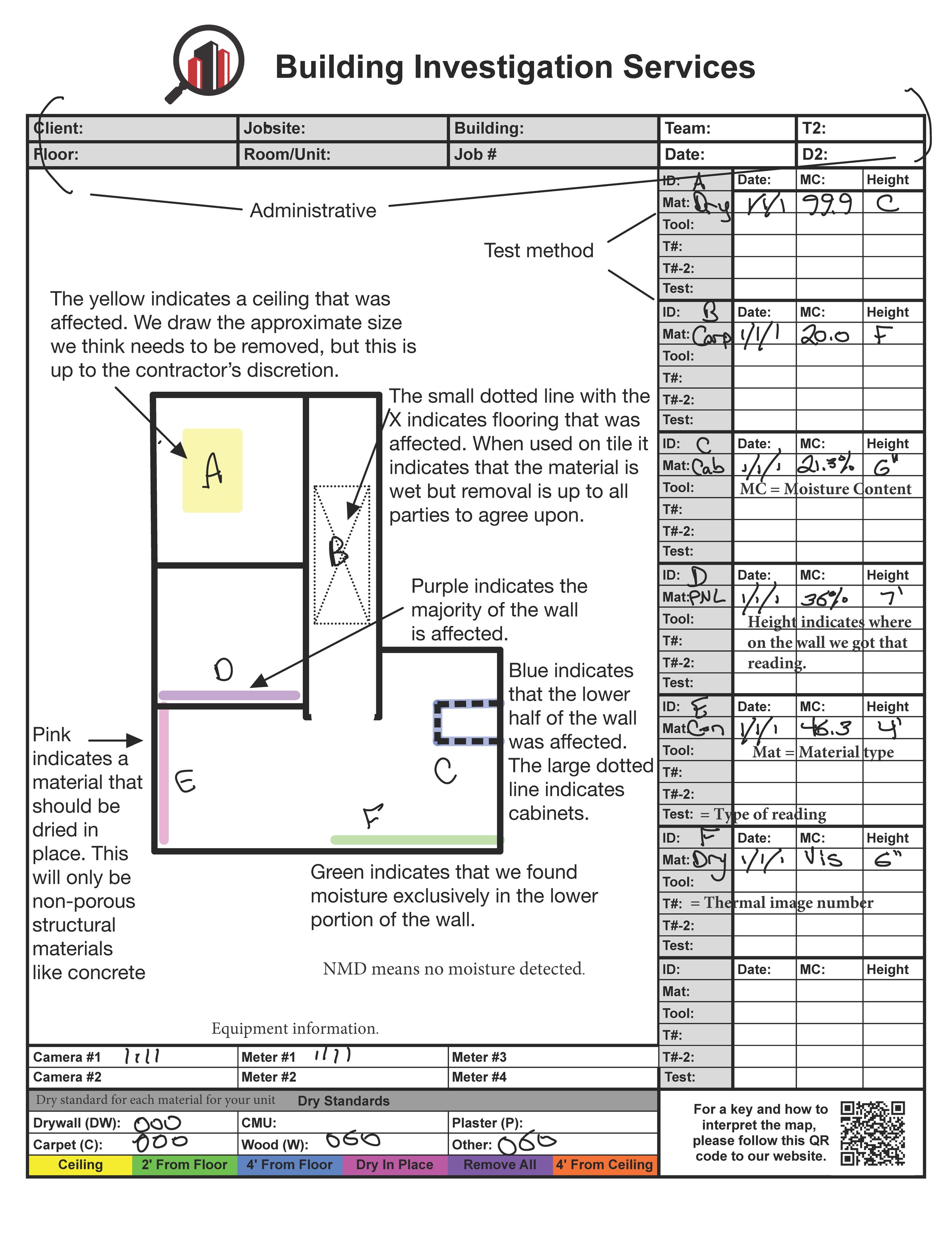
How to read our maps
While the methods we use to gather moisture data are based on science, there’s no one correct interpretation. We try to capture any damage present, without going overboard as much as possible. This is complicated by the fact that we are typically on site days, weeks, or even months after a loss. With each day that passes, materials start to dry, and conditions change. We have to make some guesses about the initial condition of the structure and what has occurred since then.
Below is an example moisture map with most of the parts explained. Trying to communicate a large amount of information about properties that are unique to each owner, which not overloading the contractor who would be performing the work, is a difficult job. The primary goal of our maps is not to be exhaustive of all possible issues at the property, but to indicate areas we suspect damage that should be further investigated during mitigation activities by a competent contractor in accordance with the IICRC S500 standards for water damage mitigation.
See the example map below: